सोमवार, २० ऑक्टोबर, २०१४

प्रबलगड आणि कलावंतीनदुर्ग

PRABALGAD & KALAVANTIN DURG


This is very tough to make a trekking plan in a middle of October heat...but anyway we succeeded

And we choose Prabalgad and Kalavantin fort as our trekking destination...

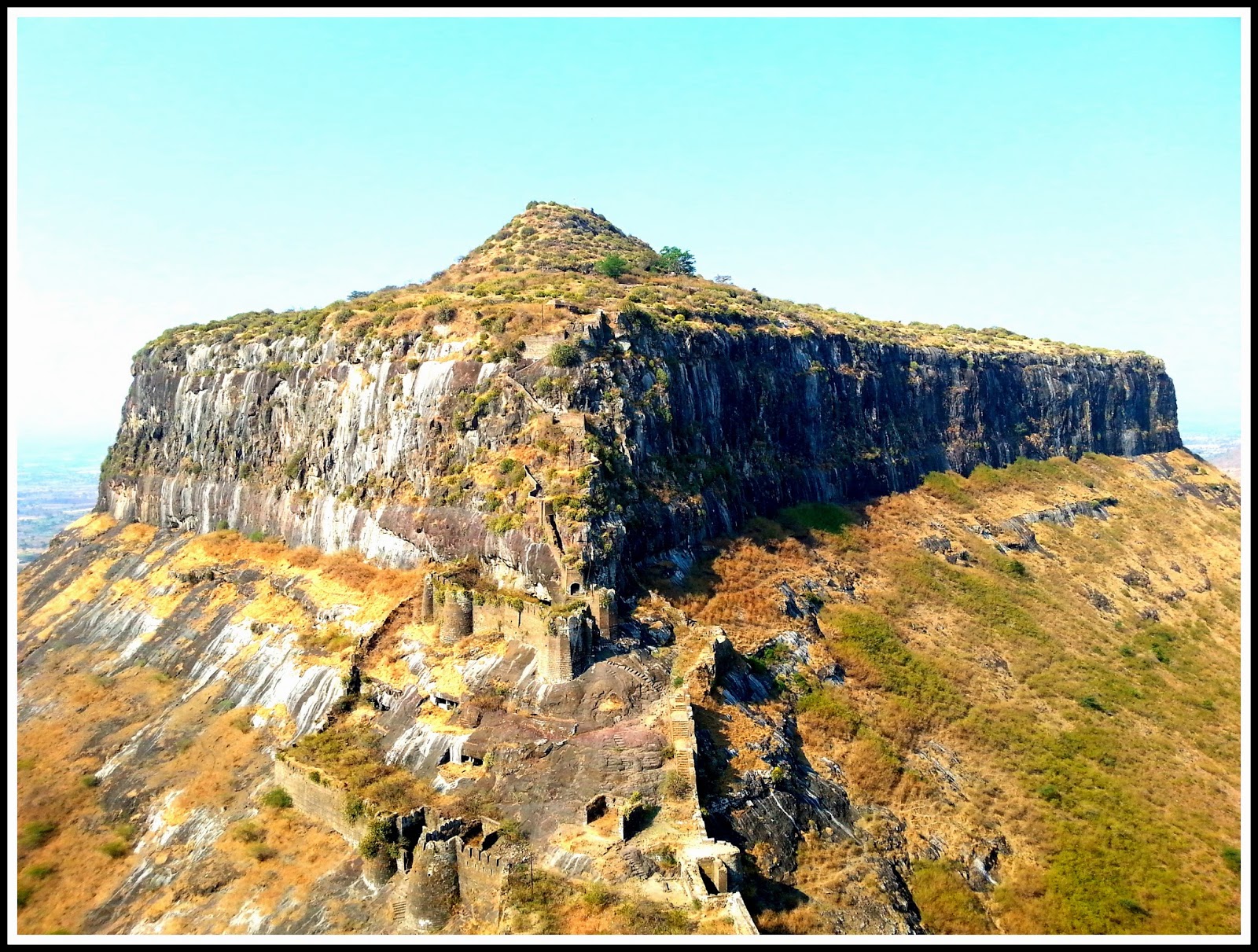
Prabalgad Fort is located between Matheran and Panvel. Hight of the fort 2300 ft.  It was known as Muranjan until it was taken over by the Chatrapati Shivaji Maharaj.


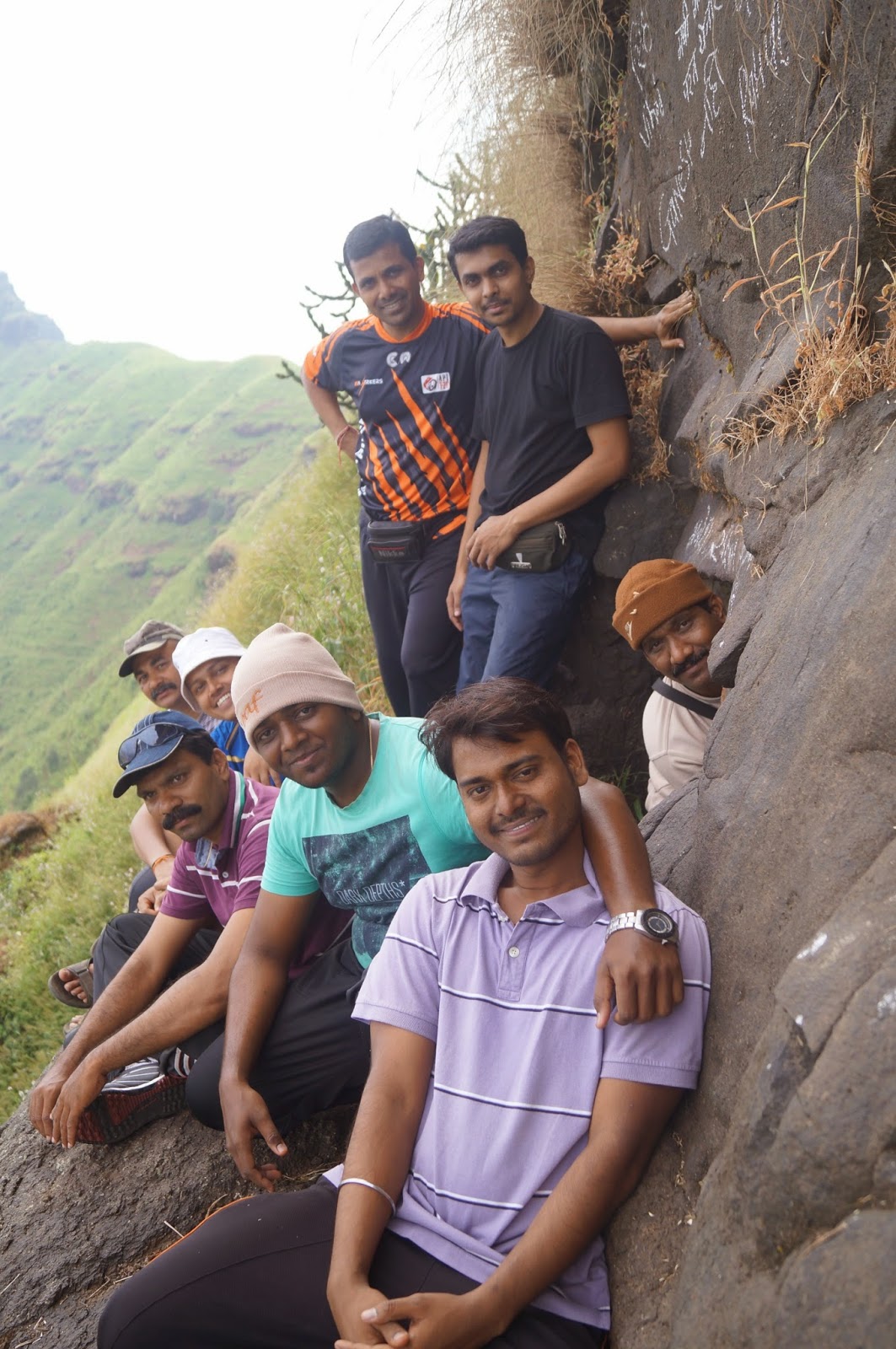
Our story :- For making our schedule more comfortable we decided to cut off at least half of distance in night and early morning so we started our journey at Saturday early evening we had five Motor-Bikes.

Around 1 am we reached at Thakurwadi village, This is the base village for both the forts. We parked our Bikes at a Hanuman Temple in the Thakurwadi. From Thakurwadi we plan to reach Prabalmachi, A small village at centre point of Prabalgad and Kalavantin Durg. Around 3 am we were on the plateau which is entrance of the prabalmachi.


Here we decide to take rest till Sunrise. In the early morning we found one small hotel cum home at the entrance of Machhi. We ask them for tea and some food and surprisingly we got best means 'Maggi Noodles'. Also we ask them to prepare lunch for us till we visit Prabalgad. At 7.30 am we started for Prabalgad. It was little stiff climb but not so difficult to reach top within 1 hr. But most time-consuming part was the searching temple, water tanks and old structures on the fort, It took around 3 hrs to find all the places on the fort which one has to visit...


Around 1 pm we reach the same hotel where we decided our lunch. After lunch and little rest at 3 pm we started our next destination....Kalavantin Durg.

Now this was very hard to reach near pinnacle in very hot temperature. It was like burning, After 15 Minutes walk Kalavantin's steps were visible to us...After climbing that huge steps in 30 minutes we were at the Top of Kalavantin Durg. 


Here we finish our trek and on the way for home.... :)   

Click to check pics by the Group :- 

https://www.sahyadriskada.com/trektoprabalgadandkalavantindurg


शुक्रवार, ३ ऑक्टोबर, २०१४

गरगड (गडगडा )


GARGAD FORT (GADGADA)

We waited from long to stop raining so we can reach an adventures destination…..GARGAD FORT
The time has come on 2nd October 2014 we decide to do Gadgada fort…

We start our journey on 1st October at night, some of our team member who were travelling from their offices has started from Dadar, Mumbai with a private vehicle. Some of we were on bike total 10 of us travelling towards Nashik for Gargad fort.

Gadgada fort is in Nashik region, Amboli Mountains.

Fort Height is around 3156 ft. To reach this fort, we took left from Wadivare Phata on Nashik Highway. After drive about 2 Km took a right turn towards Gadgad Sangavi village which is a base village for Gadgada or Ghargad Fort, we reach around 3am so decide to take rest till sunrise. We had tent so, was easy for us.


Around 7.30am we headed towards fort. The route to the fort is easy, we reach the first part where there is a well with a Shiva temple. Ghargad steps are blown off hence around 125 feet of rock climbing needs to be done to climb to the top. Ghargad steps are blown off by British hence around 100 feet of rock climbing needs to be done to climb to the top…rope and safety is compulsory.
After visit to a goddess temple we were gone to search for caves which is mention in some of trekking sites (trekshitiz) and here we did one small mistake means a wrong turn and spend 30 min to find caves. After seeing cave we came back to base of rock right side means apposite of Gadgad Sangavi village.


There is one small rock patch after crossing that we were under the leafless tress which is well grown from the rocks with the support of that tree roots we easily climb up toward the first rock patch. One of our team member who is tallest one among us Prashant start climb rock patch (Chimani climb) with the rope and then he tie rope with one tree at the end of first rock patch. Guys it was really 90° and around 15ft above. Then again after small climb there is 20 ft. climb. We use same strategy and climb up.


Around 12.15pm we at the top. After reaching top right side means toward flag you will find Mahadarwaja of fort. There are about 6-7 water tanks on top out of which only 4 hold potable water. There are some remnants of structures on top and nothing else.


In the trekking website some trekkers mention about repelling for climbing down the rock patch with one can get down at goddess temple side. But we were comfortable with the same way how we climb up so took the same route for climbing down the rock patch.

The complete trek was very adventures for all of us and most important it was first time where we used rope climb technique without any professional help.

Click link for pics of the trek - https://www.sahyadriskada.com/gargadfort

Happy Trekking :-)


रविवार, १६ मार्च, २०१४

अंकाई, टंकाई आणि गोरक्षगड


Ankai Fort


Ankai- Tankai is twin forts means they are connected to each other in very short distance. This are situated in Manmad, Nashik. There is one station named Ankai Killa station.

Ankai-Tankai Hight 961-854 m. Easy to climb.

From so many months we all are waiting for this Trek. Everytime we plan and there were always a reason to not do this location and we went on another forts. Like in my previouse post we did sarasgad, Jivdhan and all but Ankai-Tankai was that time attraction for us to do a Trek.


We started this trek early in the night from Kalyan station, we all get down at manmad station around 11.30 pm. Manmad is a well crowded city so we took some food for the night and book a cab for Ankai Kill base village. We desided to take our dinner on fort only so we started our trek in night....

Around 1-1/2 stiff climb we reached at some plateau on the fort. That was a good place to relax and take our dinner. after food we again walk for 30 min. and finally we were at the Agutsya Ashram so we decide to take nap there.


Agutsya Ashram


In morning we roam on fort for the sight seeing like over the top there are 5 caves and 7 water tanks. There was one old structure also at the end plateau on fort. We did night trek so we went directly on top of Ankai for rest but actually on the way there are Acient buddhist caves below the fort. We are already at the top so we deside to go on Tankai fort firts then visit to Caves.


At half of climb down there are some broken steps which leads to Tankai fort. Around 30-45 min small climb we reached at top of Tankai Fort. Top of the fort there is big plateau with mahadev temple and a lake. also the construction and the bastion.


Later we went down for the caves. The caves are well maintained but be aware their are lots of monkeys. Caves are also with metal gates and all cause of the monkeys. But no need to worry monkeys cause this monkeys are harmless they are thier for the channas(Chikpeas) only.

Now we are facing the 12 pm heat from the sky, of course Its march...


But we yet not declare our trek
end...cause there was one more plan for Gorakshagad
There are three caves and steps to climb on Graksha gad. So Its easy for anyone. It was difficult to reach at the Top of Hill cause it need the rope. After some rest at the Grakshnath Temple Shade we started back to our way for Kalyan.

We reached at Highways near base Goraksha Hill, Visapur road. We waited for atleast 45 min for ST or Auto. Finally we got one Truck and that was so fun to travel back to Manmad station on the Truck.

Our destinations were superb, But not in summer.....

Note: There are water available on the fort. But one should arrange food by themselves...

Happy Trekking.....

For Group Pics please click below link :
https://www.sahyadriskada.com/trektoankaitankaiandgorakshagad

रविवार, १६ फेब्रुवारी, २०१४

सरसगड

SARASGAD


Sarasgad is a village situated near Pali,  Maharashtra.
The village contains Sarasgad Fort, the twin of Sudhagad Fort. It can be identified by its four pinnacles and thus was mainly used place to check the surrounding region.There are two routes which lead to the top of this fort from Pali. On the top is the Shiva temple providing an excellent panoramic view of all the mountain ranges surrounding this area. Sudhagad and TailBaila can be easily view from the top of Sarasgad.
This fort height from sea level is 490 meters. There are many caves which were used for soldiers and other purposes because the fort has very little area available on its top. There are around ten tanks carved in rocks. They provide cool water supply throughout the year, which is very important for any fort.

We start our journey from Dadar by a private vehical. We took one halt for dinner near panvel and reach Pali around 1.30am Sunday. We got a place in Dharmalaya in Pali Village.
Early morning around 8.30am after a nice breakfast of Wadausal and tea we headed to the Sarasgad Fort. Fort is small and easy for any routine trekker. Within a hour of time we reach one of big water tank on fort.

You can find a nice Image for facinated spots on fort in google.com. which has water tanks, caves and temple etc.

After a 2 hrs of sight seeing and photografy we took return path to the Pali village. Around 12.20pm we were at the Temple of Ganeshji in Pali for Darshan.
We had nice vegetarian lunch near temple and startedback for home....
We had a own vehical so it was more comfortable for us to reach and finish our trek in time, But no worry from Thane-Pali or Karjat-Pali thier are good frequency for S.T. Buses.

Happy trekking.... 


Some Pics From Group :

रविवार, १२ जानेवारी, २०१४

जीवधन

JEEVDHAN FORT


Jivdhan (or Jeevdhan) is a hill fortress situated 45 km near the modern day town of Narayangaon in Junnar Taluka of Pune district in MaharashtraIndia. The fort, which rises 1,145 meters (3,757 feet) above sea level, is located in the Sahyadri mountain range.
Forts originated during the Satvaahan era. Every entry point on the forts built by Chhatrapati Shivaji Maharaj have a 'Kalas' and Lord Ganesh carved on it. The nearby Naneghat (Toll collection booth) was used for commercial purpose by traders to help in easy movements of goods. As this was an important pass joining the seas to the mainland, it was heavily guarded from enemies. The Jivdhan fort stood as an important guard fort to protect the interests of various kingdoms. Jivdhan to Naneghat has an open field of 2–3 km, which gives any clear indication of enemy approach. The British captured this fort in 1818 and destroyed all approaches. 


From Ghatghar village, one way goes to Naneghat and the other goes to the fort. Its much better till one reaches the steps. Some of the steps have been destroyed and it has become slippery. We had our vehicle so that was comfortable for us. We reached at 3am in morning so we took rest in caves of Naneghat and after breakfast we started out trek. It took 3 hrs to reach at top.

There are so many thing on fort to see. Such as storehouse is quite huge and is the sole construction, which has remained so intact. It is highly decorative and height is about 4 meters. The pillars are carved out in rock and they are decorated by carving arts, which resemble open hood of a cobra.


There are a few cisterns, but those on the western side of the topmost hillock consist of potable water. There is Idol of Goddess Jivai. Once you are at the top of the fort you can view various hilltops and forts nearby. You will clearly see forts like Harishchandragad, Chavaand, Ratangad, Naneghat, Manikdoh Dam and the entire Junnar plateau. 


Some Pics From Group: